columbia river shadows
2013-2014 Collaboration with kerry davis
The river of dazzling droplets,
Freezes the light
Is the light.
-Derek Sheffield
From As a Species Flies From Extinction, Consider The River
You stay in the mainstem, press upstream through grassland and farms. You feel the river’s pace quicken as you enter the Hanford Reach – one of the Columbia’s last “free flowing” sections. You pass by the B-reactor, which produced the plutonium for the bomb that was dropped on Nagasaki and killed 100,000 people. Nine nuclear reactors, some of which are now dismantled, perched on the banks of the Columbia and produced 75% of the U.S. nuclear weapon capabilities from 1945 through the 1980s. Today, Hanford is the most contaminated place in the Western Hemisphere due to huge stockpiles and spills of radioactive waste. You swim faster.
-Columbia Riverkeeper
From Swimming Upstream, the Journey of Columbia River Salmon

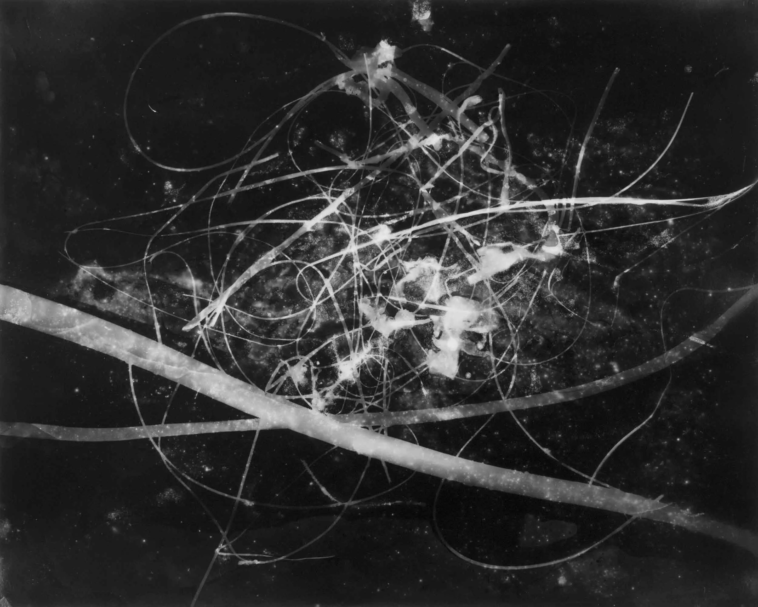
Untitled (Hanford Reach, 370 miles from the Pacific Ocean), Ripple-sculpted unique gelatin silver photogram, 42” x 55” x 5”

Untitled (Hanford Reach, 370 miles from the Pacific Ocean), Ripple-sculpted unique gelatin silver photogram, 42” x 55” x 5”
One element that connects us all is water and the Columbia River is the lifeblood of our entire region. Columbia River Shadows is a series of large-scale photograms made at ten sites along the Columbia River from the Hanford Reach to its mouth on the Oregon Coast. The images were created by submerging up to 8’-long sheets of photosensitive paper directly in the waters at night, exposing them to a flash of light and then developing the silver-gelatin prints in the darkroom. The work is related to the artists' earlier collaboration, Shadows, which evoked the shadows left by victims who were vaporized by the atomic bombings of Hiroshima and Nagasaki. In a continuation of the nuclear theme, the artists started at the Hanford Nuclear Reservation Site in southeast Washington State where the plutonium was developed for the bomb dropped on Nagasaki. Reflecting on interdependence, this project alludes to such interrelated themes as migration, water politics, the Great Pacific garbage patch and the atomic era.
Hanford is reportedly the most contaminated place in the Western Hemisphere, where billions of gallons of radioactive waste have been dumped on the banks and into the river itself. Downstream, photograms were made at the former Celilo Falls, a tribal fishing area for fifteen thousand years until 1957 when the falls were submerged by the construction of The Dalles Dam. Additional sites included the mouth of the Sandy River during the smelt fish run, the confluence of the Willamette and Columbia Rivers in industrial urban Portland, and Clatsop Spit near the Lewis and Clark Expedition winter encampment.
As a meditation on the challenges of comprehending and bearing witness to the global environmental crisis, the project foregrounds the ideas of presence and immediacy. The river and ocean waters which flowed directly over the photographic paper, the smelt fish, plastic detritus and invisible toxins – all left palpable traces of their presence. As records and evocations of these ephemeral moments of contact, the photograms invite haptic sensing in addition to visual and intellectual perception, and suggest the possibility of embodied and experiential understanding of overwhelming environmental concerns.

Untitled (Celilo, 200 miles from the Pacific Ocean), unique gelatin silver photogram, 42” x 96”

Untitled (Wahkeena Falls, 125 miles from the Pacific Ocean)

Untitled (Columbia Slough, 106 miles from the Pacific Ocean), unique gelatin silver photogram, 42” x 96”

Untitled (Columbia Slough Detail, 106 miles from the Pacific Ocean)

Untitled (Confluence of the Willamette & Columbia Rivers, 105 miles from the Pacific Ocean)

Untitled (Confluence of the Sandy & Columbia Rivers - Smelt run, 115 miles from the Pacific Ocean)

Untitled (Clatsop Spit, Pacific Ocean)

Untitled (Clatsop Spit, Pacific Ocean)

Untitled (Bull Kelp, Oregon Coast)

Untitled (Oregon Coast)

Untitled (Columbia River)

Untitled (Oregon Coast)

Untitled (Oregon Coast)

Untitled (Columbia River)
Untitled (Oregon Coast)